


 Off a narrow road in a swampy part of Staten Island, Thomas Morello is preparing his two-family home for the next time the water pours in from Lower New York Bay, a quarter mile away.
When Hurricane Sandy hit more than eight months ago, inundating but not destroying his converted summer cottage, Morello discovered the house was not anchored to its foundation.
Now, as he repairs the damage from water that rose almost to the second floor, he is bolting and screwing the structure to its pilings. He has moved its electrical and heating systems near the roof. A previous owner had taken the most critical step, elevating the house about 6 feet.
Soon, the city will make similar preparations but on a grander scale. Under a $19.5 billion blueprint released last month, New York outlined ambitious plans to fortify itself not only against the next big storm, but against seas that scientists say could rise 2 feet by the 2050s and other climate-related challenges, including heat waves.
The 438-page plan, which involved a neighborhood-by-neighborhood survey of potential problems along 520 miles of coastline, vaults New York to the forefront of U.S. resilience planning, experts said, along with the Gulf Coast of Louisiana, which released its $50 billion plan last year.
"New York City's sophistication in approaching climate adaptation is way at the top," said Debra Knopman, vice president and director of the Rand Corp.'s justice, infrastructure and environment division, who has worked with Louisiana and is familiar with New York's effort. "It's a very, very impressive report."
Still, many are waiting to see whether New York can and will follow through. That might depend on whether the next mayor is as committed to resilience planning as Mayor Michael Bloomberg, and whether the city can find the remaining $4.5 billion needed to carry out its plans. Officials acknowledge that they will be returning to a deeply divided Congress for more money and to the Federal Emergency Management Agency for regulatory changes that will enable some of their efforts.
"The question is whether Sandy is enough of an impetus to maintain and sustain a plan like this," said Jordan Fischbach, a policy researcher at Rand. "Is it close enough to the top of the list, and will it compete with other priorities in the decade or two to come?"
As Morello, a carpenter, and city officials can attest, adapting to climate change is generally not technologically complex. It is mostly about raising homes, buildings and other vital facilities to escape rising seawater or building barriers. It is about taking advantage of the natural topography to help sap the strength of damaging storms, waterproofing and protecting critical infrastructure such as electrical grids, assessing the possible results of prolonged heat and drought, and trying to mitigate them.
"It's not rocket science. A lot of these things are things we do already," said Jessica Grannis, adaptation program manager at the Georgetown Climate Center at Georgetown University Law Center, a clearinghouse for information on such preparations. "It's just tailoring them to a changed future."
Nineteen states and many localities, including Washington, are preparing such plans, according to Vicki Arroyo, the Georgetown center's executive director. Chicago, which faces little flood danger, is figuring out how to cope with increasing heat.
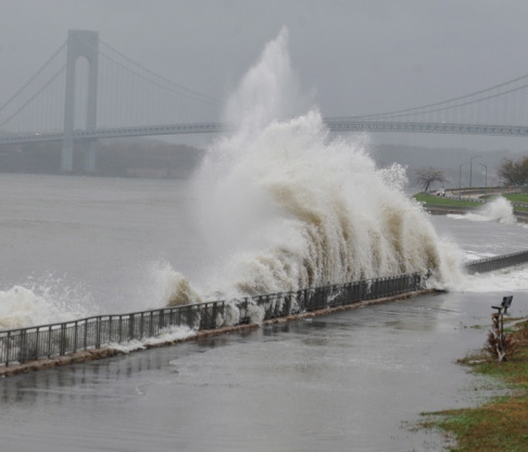
Still, the sheer scope of what New York hopes to protect is staggering. Under the FEMA maps last issued in 1983, 33 square miles of the city, or 11 percent of its land, were in danger of flooding in a 100-year storm -- a storm that has a 1 percent chance of occurring in any year. Preliminary 2013 maps have increased that to 48 square miles. By the 2050s, 72 square miles, or 24 percent of the city, will face that danger because of sea-level rise.
About 398,000 homes will be in those flooding zones under the new FEMA maps. (The city has more waterfront than Miami, Boston, Los Angeles and San Francisco combined.)
The plan calls for an array of solutions.
On Staten Island's eastern shore, for example, the city wants to build levees and flood walls, some 15 to 20 feet high, that would protect, among other places, Morello's Midland Beach neighborhood.
On Newtown Creek, the Army Corps of Engineers would build surge barriers that would close during storms to keep water out of Long Island City. The hard-hit Rockaway Peninsula would get a dune system, including a double dune in Breezy Point, where 126 homes burned down during Sandy.
Coney Island's beaches would be renourished, and breakers might be installed off the shores of Staten Island and the Bronx's City Island to dampen waves. A wetlands restoration project in Queens is designed to do the same thing.
The most innovative project might be construction of a "Seaport City" atop a levee designed to protect the East River shoreline south of the Brooklyn Bridge.
Modeled on Battery Park, the area would be home to residences and commercial development.