


 Less than 18 months after the US Army Corps of Engineers blasted gaps in a levee on the Mississippi River to cope with a record flood, it's getting ready to detonate explosives for the opposite reason to clear rock outcroppings on the bottom of the drought-depleted waterway so cargo can keep moving.
"From one extreme to another in just the space of 12, 15, 16 months? It's just incredible," says Richard Heim, a drought specialist at the National Climatic Data Center in Asheville, N.C.
The time last year, the drought in the continental US was largely confined to the its southern tier. Since mid-July, however, between 60 and 65 percent of the continental US has been experiencing moderate-to-exceptional drought (though the figure slipped below 60 percent for two weeks in November), according to the National Weather Service's Climate Prediction Center in College Park, Md.
While forecasters expect some easing of drought conditions during the next three months in patches around perimeter the drought's vast core, drought is expected to persist or intensify from the Southwest up into the Rocky Mountain states.
Even in a year that saw hurricane Sandy, the drought could be the headline severe-weather event of 2012.
Initial estimates range from $60 billion to $100 billion, with a first official estimate from the US Department of Agriculture expected in February, says Steven Cain, a specialist with Purdue University's Agriculture Communications Service in West Lafayette, Ind.
By some estimates, Sandy inflicted at least $75 billion in damage.
So far, hurricane Katrina in 2005 tops the costly-weather-event list at about $108 billion. Still, Mr. Cain says, the country faces the prospect of dealing with what are likely to be two of the three most expensive weather-related disasters on record in the same year.
"That's going to be an amazing recovery situation," Cain says.
In 2010 and 2011, the southern tier bore the brunt of drought conditions, thanks to back-to-back winters where La Nia held sway in the tropical Pacific. Over North America, a La Nia pattern tends to shove average storm tracks farther north than usual. Coming out of the winter of 2011-12, much of the US heartland saw virtually no snow cover 14 percent of the continental US was covered in snow, compared with 56 percent in January 2010.
This contributed to record high temperatures in some locations in the center of the country in March and helped fuel the high summer temperatures as well. The soil held little moisture that, through evaporation, could help shave a few degrees off of summertime highs. And the lack of snow cover meant substantially less snow melt to help fill rivers.
Within the region's agriculture sector, the heaviest toll appears to be falling on farmers who focus on livestock, Cain notes. Many crop growers have crop insurance, while those who focus on livestock don't. With fodder either too expensive or unavailable, many are having to liquidate herds, he says.
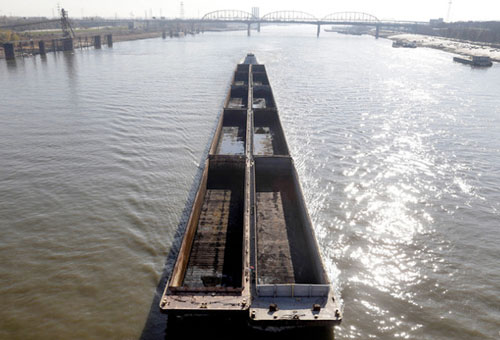
Then there is the matter of getting what crops farmers could harvest down the Mississippi to waiting export markets.
Graineries in St. Louis reportedly loaded their last barges until further notice Friday, according to Lynn Mench, a senior vice president with the American Waterway Operators (AWO), based in Arlington, Va. Grain shippers are opting to halt their work rather than send barges down partially loaded, which gets them down river but at a higher cost to the grain's buyers. Sending them fully loaded could result in the barges running aground and remaining stuck until water levels rise.
Restrictions on barge capacity also affect winter-friendly commodities coming up river from road salt to coal that power plants need to keep generators humming. Other forms of transportation will try to pick up the slack, but at higher cost.
One inch in a barge's hold represents about the same capacity as one semi truck, Ms. Mench notes. Where normally barges will be loaded to a 12-foot draft, conditions now are limiting them to about 7-1/2 feet a loss of about 54 trailers' worth of capacity per barge.
To help keep the St. Louis-to-Cairo run navigable for as long as possible, the US Army Corps of Engineers is getting set to blast away rocks on the river bottom near Thebes, Ill. But that may not happen until early January.
Potential relief lies up the Missouri River, where a chain of reservoirs is storing water for flood control, irrigation, and navigation. Water for navigation typically gets released beginning April 1. But AWO and other organizations are urging Washington to instruct the Corps to release a small fraction of that water to keep the affected stretch of the Mississippi navigable. Concerns also extend to low levels in the Illinois and lower Ohio Rivers.
The Missouri and Mississippi River basins "need 3 to 12 inches of rain just to catch up," Mench explains. Snow won't cut it, because it remains frozen until spring. If the Corps waits until April, "there's a real possibility that we could either be shut down or severely limited in what we're moving for four months."
And if the drought continues well into next year? "If this gets more serious, we're going to have issues between towns and farms in terms of water," Cain says, setting up potential conflicts over water rights that Western states have struggled with for a century or more.